The facility maps have been a core feature of Dock411 since we started, which is why we are so excited to announce a significant improvement to our mapping capabilities! The updated facility map is easy to use for both drivers and shippers. However, the old map will still work, so if you can’t jump in and make updates to your facility right away, all of your original information will still be available. Today we’re going to dive into the new features and show you how to maximize the usefulness of our new facility maps.
Regions vs. Single Locations
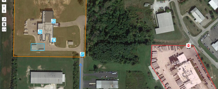
In our original facility maps, each facility was defined by a single point. The exact latitude and longitude of that point was where we mapped the facility to be. Of course, facilities are much larger than that. Many shippers have multiple buildings that comprise a single facility, for example, or a warehouse that covers a significant amount of space. That’s why our new map introduces regions. You can use a simple drawing tool on the map to define a region that encompasses your entire facility, whether it’s one building or five. That gives you a lot more flexibility in defining where your location is and gives drivers a more accurate view of the operation.
Put Markers to Define Specific Features
As a shipper, you might want to let drivers know that there’s a check-in hut at a specific location, or that there’s a hazard to avoid along one road. As a driver, that kind of information saves you countless hours and gets you back on the road much more quickly. Our new facility map allows shippers to use icons to denote X different types of features, from entrances to hazards to where to get fuel. As a result, the drivers who deliver to you get a much more detailed understanding of your layout, which saves everyone time and money. The ability to define specific features is available to every shipper, so take a few minutes to explore your options and improve your map. The drivers and carriers who work with you will be glad you did!
Draw Routes
One of the things standard maps don’t do well is let you know the best way in to a location. For example, there could be narrow roads on one side that should be avoided or a particular route that’s more smoothly paved than other options. On top of that, there are sometimes one-way streets, construction, and closures that aren’t shown on a map. Or, a facility might have multiple warehouses but only one that takes specific deliveries. That’s why we introduced the ability to draw routes. Shippers can use a simple drawing pen within Dock411 to draw the best route for a driver to follow when making a delivery. That eliminates the guesswork and allows drivers to bring you what you need in the most efficient way. You get your delivery in the right place at the right time and the driver can make a drop and get back on the road quickly. Everyone wins when you draw the best route on the map!
Use Our Facility Map Today
Our new map is available for all 400,000 facilities in our current database. If you’re a shipper, log into your account and try it out! You’ll have fun defining your spaces, adding features, and showing everyone the best route. As we mentioned earlier, if you don’t have time right now, don’t worry — the old map is still available as well. Our maps are designed to be as useful as possible, which is why the Dock411 team is personally updating the most-visited facilities to the new map with properly defined areas and features. But if you are a shipper, don’t wait for us — jump in and update yours today. If you’re a driver, you’ll start seeing these new features on many facilities soon. We’d love for you to give us feedback, so download our app and try it out today!