Trucking And Logistics Need a New Way To Specify Location – Part 1
This article is the first in a series in which I’m going to review the costs and consequences of using street addresses in trucking and transportation. I will also look at several alternative ways of referring to a location.
Almost anyone with a smartphone and a need to get somewhere is familiar and comfortable with using the phone’s built-in mapping software. You open the app, enter the street address, and follow the little blue line to your destination.
Street addresses work okay for personal use, but they are not perfect. We’ve probably all had situations where we were given an address and still had some difficulty finding our exact destination.
Sometimes the building or store is located on the other side of the street, or around back, or is one of many shops tucked in a long strip mall. As a consumer in a car, it’s relatively easy to simply find a parking space and walk around to find the final destination.
If you’re behind the wheel of a box truck or 53ft tractor-trailer, it’s not so easy. Those slight problems are magnified and end up costing money. While you might be able to do a quick U-turn in your car, you can’t do that in a big truck.
As we’ve talked with drivers, operations staff, and dispatchers over the past few years, we’ve heard countless stories of delays and lost revenue due to confusion caused by street addresses.
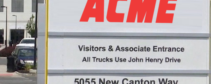
We’re even more keenly aware of the problem because Dan, my co-founder at Dock411, saw it on a daily basis. He was a warehouse manager in one of the industrial parks around O’Hare airport. The building was older, but not otherwise unusual. Offices in the front facing the street, dock doors and parking on both sides of the building.
They regularly had drivers stop in the middle of the road out front, get out of the cab, walk into the office and ask if they were at the right place. They had put the street address into their mapping software and it said they had “arrived”. And they had, right at the front door for the corporate offices of the company. Unfortunately, as it happens thousands of times a day to truck drivers across North America, that’s not where they needed to be.
That cycle of the driver pulling up, double-checking his map and paperwork, getting in and out of the cab resulted in a fifteen to twenty minutes delay. And those types of delays multiplied by hundreds of thousands of times a day add up to real time and money.
How much money? If we assume address problems cause an average of five minutes of delay for the 3 million drivers in the U.S., it works out to 15 million minutes or 250,000 hours of lost productivity.
So, what is the solution? Ultimately, what the industry needs is a tool for specifying a location for trucking, logistics, and transportation that has these characteristics:
- Uniquely identify a location
- Easy to repeat over the phone
- Easy to understand and type
- Easy to add to existing systems
- Can move with a location (because construction, growth, etc)
In this series of articles, I’m going to look at six different systems for specifying location:
- Street address
- Lat/Lng
- what3words
- Geohash
- Google “Plus Codes”
- D411 ID™
For each, I’ll cover a bit of its history and intent, review the pros and cons of using them when trying to route a truck to a particular spot on earth, and finally, see how they measure up against our requirements.
In the end, I hope to make a clear, compelling case for a better way for trucking, transportation, and logistics to specify location. And if you have feedback or thoughts, let me know.